

Tanzanian ex-ambassador and government critic abducted, family says
Update | More KZN beaches closed in anticipation of tropical cyclone Batsirai
10:57 CAT | 04 Feb 2022
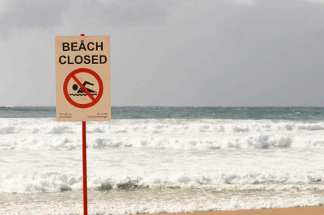
The eThekwini Municipality has closed all beaches in the north and south of the City.
The City said in a statement that all beaches in eThekwini, from north to south, are closed as a result of the shark nets being removed by the KZN Sharks Board.
This includes Umhlanga Rocks beaches and the Durban Beachfront.
On Thursday, the KZN Sharks Board had started removing all shark safety gear along the KZN coast, ahead of tropical cyclone Batsirai, expected to make landfall in southern Mozambique early next week.
“This closure takes effect immediately and there will be no bathing allowed.
“The Sharks Board have removed all the shark nets to prevent unnecessary losses and/or damage to their equipment as a result of strong winds and heavy seas associated with predicted severe weather systems,” the City said.
The KwaDukuza Municipality, on the KZN North Coast also closed all its beaches on Thursday until the cyclone has passed and the shark safety gear is restored.
Meanwhile, the South African Weather Service (Saws) says it is too early to determine if and how South Africa will be affected by the cyclone.
Batsirai passed Mauritius on Wednesday, dumping heavy rain and blasting winds of up to 120 kilometres per hour.
According to Saws chief forecaster Kevin Rae, it seems highly likely that the eastern coastline of Madagascar, particularly the central part of the coast will bear the brunt of strong, damaging winds and torrential rainfall, as Batsirai makes landfall at some stage in the latter half of Saturday, February 5.
Intense tropical cyclone #Batsirai now barreling towards #Madagascar and will hit the island by Sat afternoon. After moving into the Mozambican Channel on Sunday the storm should turn south avoiding southern #Mozambique and eastern #SouthAFrica. pic.twitter.com/6BvE0ycHtw
— Weather Master #Sangomasezulu (@JoelGuy_) February 4, 2022
“Very rough seas, combined with storm surge, tend to be more extreme on the southern (poleward) side of tropical storms in this region of the world.
“Moreover, the steep, rugged topography of the mountains extending along the eastern coastline of Madagascar, will no doubt, exacerbate the risk of orographically-induced rainfall as well as flash-floods and mudslides.”
He said it was key to acknowledge that the movement of tropical cyclones can be extremely erratic.
“…hence challenging to predict with any accuracy, it is difficult to speculate about future movement of Batsirai in the timescale beyond this weekend. Meteorologists are however confident that Batsirai will weaken temporarily once it makes landfall over Madagascar. It is also probable that Batsirai will re-invigorate as it enters the ocean environment of the Mozambique Channel, early next week,” he said.
Rae explained that despite significant recent advances in Numeric Weather Prediction (NWP) and super computing, it is not yet possible to accurately determine whether Batsirai will eventually affect South Africa, either directly or indirectly.
“However, the latest ensemble forecast from the European Centre for Medium-Range Weather
Forecasts (ECMWF) provides a good idea of the most likely path and movement of Batsirai during the coming five days. Suffice to say that, at least in the days ahead, there is no immediate weather-related threat for South Africa, in relation to this tropical cyclone. Be assured that Saws will continue to closely monitor developments in this regard and will issue updates as and when necessary.”
Show comments
Also read


Leave a Reply
Be the First to Comment!
You must be logged in to post a comment.
You must be logged in to post a comment.