

Maputo Province: Over 290 Mozambicans repatriated from South Africa await return to areas of origin
Tropical Storm Kenneth to threaten Mozambique, Tanzania later this week – AccuWeather
8:25 CAT | 24 Apr 2019
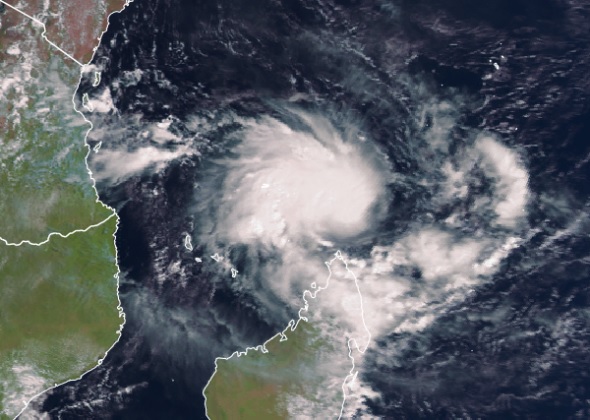
Satellite image of Tropical Storm Kenneth near Madagascar on Tuesday, April 23.
A new tropical threat in the southern Indian Ocean may bring life-threatening weather to parts of Mozambique and Tanzania later this week.
Kenneth underwent additional strengthening on Tuesday, and has been rated a moderate tropical storm by Meteo France, the French national meteorological service.
A moderate tropical storm is equal to a tropical storm in the Atlantic and East Pacific oceans and contains sustained winds of 63-87 km/h (39-54 mph).
Prior to reaching the eastern Africa coastline, Kenneth will enhance rainfall across far northern Madagascar into Wednesday.
Locations from Ambanja and Antisiranana to Andapa and Antalaha will be at risk for localized flash flooding and travel disruptions. Downpours can bring a quick 25-50 mm (1-2 inches) with locally higher amounts possible.
Seas will also build along Madagascar’s northern coastline into Wednesday, resulting in dangerous conditions for bathers and small craft operators.
Mayotte and Comoros will be the next locations at risk for significant impacts from Kenneth.
The heaviest rainfall is expected from Wednesday into Wednesday night.
Mayotte may dodge the worst conditions as the strengthening storm tracks north of the island, bringing 25-75 mm (1-3 inches) of rainfall and gusty winds.
Comoros will endure a longer period of stormy weather as Kenneth may strengthen into a tropical cyclone or intense tropical cyclone, producing 75-150 mm (3-6 inches) of rainfall and damaging winds. Wind gusts up to 130 km/h (80 mph) will be possible across the islands.
Dangerous seas will batter the island’s coastal locations into Thursday.
Further strengthening is possible into Thursday as the storm approaches the southern coast of Tanzania and northern coast of Mozambique.
Downpours may reach coastal locations by the end of the day on Wednesday before increasing in coverage and duration Wednesday night and Thursday morning.
At this time, landfall of Kenneth could occur as early as midday Thursday near the border of Tanzania and Mozambique. If Kenneth tracks slower and has more time to strengthen, landfall may not occur until Thursday night.
Areas near and just inland of this landfall location will be at risk for flooding rainfall, mudslides and damaging winds.
Locations from Lindi, Tanzania; to Pemba, Mozambique; are most likely to experience the worst of this storm.
While interaction with land will cause Kenneth to weaken as it slowly drifts just inland from the coast, torrential rainfall can still trigger flooding and mudslides for locations such as Masasi and Tunduru in Tanzania and Marrupu and Montepuez in Mozambique.
Kenneth may stall or meander over areas just inland from the coast in northern Mozambique and southern Tanzania through this weekend.
Rainfall amounts of 200-300 mm (8-12 inches) are expected from Wednesday through Sunday with an AccuWeather Local StormMax™ of 500 mm (20 inches).
This amount of rainfall can result in life-threatening flooding and lead to homes being inundated by floodwaters. There will also be an elevated risk for mudslides in areas of rugged terrain.
The areas that are most at risk from Kenneth were largely spared from any of former Tropical Cyclone Idai’s destruction in March.
Many locations in central Mozambique, including Beira, suffered catastrophic damage and are still trying to rebuild and recover from Tropical Cyclone Idai more than a month after the storm’s landfall.
By Eric Leister
- AccuWeather senior meteorologist
Source: AccuWeather
Show comments
Also read


Leave a Reply
Be the First to Comment!
You must be logged in to post a comment.
You must be logged in to post a comment.