

Mozambique: Two hotels, 21 offices and more seized by the Attorney General's Office in 2024
Tropical Cyclone Hidaya develops east of Tanzania, to affect northern Mozambique
9:53 CAT | 02 May 2024
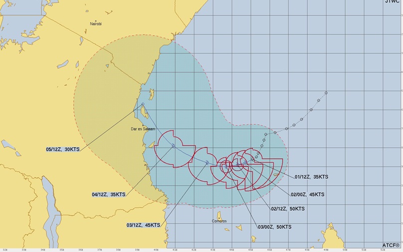
Image: Meteo France
Tropical Cyclone Hidaya developed over the South Indian Ocean east of Tanzania on Wednesday.
At 11:00 a.m. EDT on Wednesday the center of Tropical Cyclone Hidaya was located at latitude 8.6°S and longitude 45.0°E which put it about 2250 miles (360 km) north-northeast of the Comoros. Hidaya was moving toward the west at 4 m.p.h. (6 km/h). The maximum sustained wind speed was 40 m.p.h. (65 km/h) and there were wind gusts to 50 m.p.h. (80 km/h). The minimum surface pressure was 999 mb.
A former tropical depression over the South Indian Ocean north-northeast of Comoros strengthened on Wednesday and Meteo France La Reunion designated the system as Tropical Cyclone Hidaya. Thunderstorms were occurring near the center of Hidaya’s circulation. Bands of showers and thunderstorms were revolving around the center of circulation. Storms near the center of Hidaya generated upper level divergence that pumped mass away from the tropical cyclone. Winds to tropical storm force extended out 100 miles (160 km) from the center of Tropical Cyclone Hidaya.
Tropical Cyclone Hidaya will move through an environment favourable for intensification during the next 24 hours. Hidaya will move over water where the Sea Surface Temperatures are near 29°C. It will move under the western end of the axis of an upper level ridge over the South Indian Ocean. The upper level winds are weak near the axis of the ridge and there will be little vertical wind shear. Tropical Cyclone Hidaya is likely to intensify during the next 24 hours.
Tropical Cyclone Hidaya will move around the northern side of a high pressure system over the South Indian Ocean. The high pressure system will steer the Hidaya toward the west during the next 24 hours. On its anticipated track Tropical Cyclone Hidaya will move north of Comoros on Thursday. Hidaya will bring gusty winds and locally heavy rain to Comoros. Heavy rain is likely to cause flash floods in some locations. Tropical Cyclone Hidaya could approach the coast of Africa near southern Tanzania and northern Mozambique later this week.
40mph #Hidaya forecast to peak at 60mph Severe TS then weaken to TD when it impacts coastal areas of #Tanzania,#Kenya incl #Daressalaam,interests there should begin preps and watch out for life threatening #Flooding Rains/#Mudslides!#Wxtwitter #TropicsWx #Cyclone #CycloneHidaya https://t.co/nrL6zAln6e pic.twitter.com/tcY5dNk6c2
— LimWx (Off Season from Hurricanes) (@LimWeather) May 2, 2024
#CycloneHidaya has formed east of Tanzania. Slight strengthening is forecast before it weakens as it approaches the coast late in the weekend. The main threat with be rain and some gusty winds.#Hidaya #23S pic.twitter.com/BaeUlCHWKm
— Mike Adcock (@MikeAdcockWx) May 1, 2024
Tropical Storm #Hidaya has formed to the east of #Tanzania. Some strengthening likely as the storm moves slowly westwards, but then weakening is expected before the storm reaches the coast pic.twitter.com/hzHuwUwSay
— Met Office Storms (@metofficestorms) May 1, 2024
Moderate TS #Hidaya has formed just north of #Comoros & #Mayotte & will bring spells of heavier rain to the islands through Friday. Hidaya will impact parts of #Tanzania this weekend with flooding rains & gusty winds. pic.twitter.com/ho9z7dnxnj
— Jason Nicholls 💙 (@jnmet) May 1, 2024
Source: jayhobgood.com
Show comments
Also read


Leave a Reply
Be the First to Comment!
You must be logged in to post a comment.
You must be logged in to post a comment.