

Mozambique: Training Inhassoro and Vilankulo practitioners in Nature-based Solutions for climate ...
Mozambique Channel: Severe Tropical Storm Cheneso expected to turn southwest
7:00 CAT | 25 Jan 2023
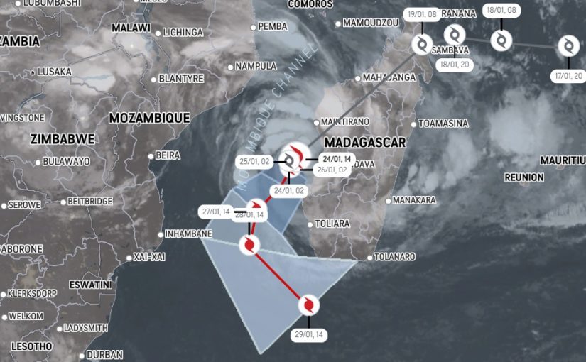
Image: AccuWeather
- Tropical storm system Cheneso has reformed in the Mozambique Channel and has strengthened into a severe tropical storm Jan. 24.
Mozambique’s National Institute of Meteorology (INAM) had warned that Tropical Storm Cheneso, the first extreme weather event of the 2022/2023 rainy season in Mozambique, could evolve into a Severe Tropical Storm, which it did. “Cheneso is now a Severe Tropical Storm and will likely become a Tropical Cyclone in the next day or two,” according to senior meteorologist/international forecasting manager at AccuWeather Jason Nichols. “A turn to the southwest will allow Cheneso to pass south of Madagascar this weekend,” Nichols added in his latest update on Twitter at around 11.30 pm yesterday.
#Cheneso is now a severe TS & will likely become a tropical cyclone in the next day or two. Storm will continue to batter parts of W #Madagascar with heavy rain & gusty winds into Friday. A turn to the SE will allow Cheneso to pass S of Madagascar this weekend. pic.twitter.com/pU5KBNSCN0
— Jason Nicholls (@jnmet) January 24, 2023
Forecast models, cited in a Crisis24 update on Cheneso, indicate the system will strengthen into a tropical cyclone as it remains quasi-stationary in the Mozambique Channel Jan. 24-25. The system is expected to stay well over 100 km (62 miles) off the west and then southwest coasts of Madagascar as it tracks southwestward then south-southwestward Jan. 26-28, briefly reaching intense tropical cyclone strength Jan. 27 before weakening again into a tropical cyclone. The system is expected to take a turn to the southeast late Jan. 28, but will continue to stay offshore of Madagascar’s southwest coast before starting to move away from the south coast Jan. 29. Due to the strength of the storm, impacts are expected along the west and southwest coasts of Madagascar, and possibly the southeast coast of Mozambique, as the system passes Jan. 24-29. Some uncertainty remains in the track and intensity forecast, and changes could occur in the coming days.
The effects of the system are already being felt in Mozambique, along the coastal districts of the provinces of Nampula and Zambézia, where INAM warns that strong winds of up to 100 kilometres per hour and gusts of up to 130 kilometres per hour may occur, which could agitate the sea and generate waves as high as 10 metres between parallels 14 and 22 degrees south with heavy to very heavy rain (more than 200 millimetres in 24 hours) accompanied by thunderstorms.
#Cheneso has re-intensified and has reached tropical storm status. Cheneso is expected to reach cyclone status either late Wednesday or early Thursday. Cheneso has already developed a visible eye, as per the 1pm satellite images. 1/2 pic.twitter.com/DRiBn3Wnl9
— ZIMCAST (@ZIM_CAST) January 24, 2023
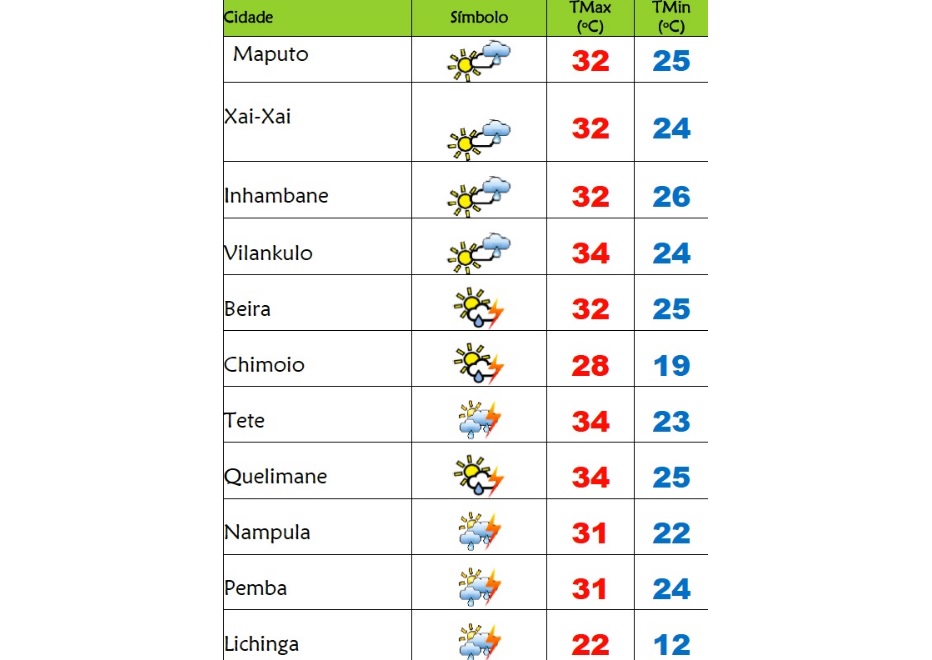
Meanwhile, INAM weather forecastsfor this Wednesday (25), the 280th day of Public Health Emergency in Mozambique, are:
In the provinces of Niassa, Cabo Delgado and Nampula very cloudy skies with thunderstorms and showers or weak to moderately heavy rains locally; Light to moderate northwest to southeast winds, sometimes with gusts along the coastal strip.
For the provinces of Tete, Zambézia, Manica and Sofala, partly cloudy skies with periods of very cloudy weather are forecast; Thunderstorms and showers or light to moderate locally heavy rain. Light to moderate northwest to southwest wind blowing, sometimes with gusts.
In the provinces of Inhambane, Gaza and Maputo, INAM predicts slightly cloudy skies temporarily very cloudy; Possibility of thunderstorms and showers or local light rain; Weak to moderate southeast wind blowing, sometimes with gusts.
Here are the temperatures expected today:
Source: A Verdade / AccuWeather/ Crisis24
Show comments
Also read


Leave a Reply
Be the First to Comment!
You must be logged in to post a comment.
You must be logged in to post a comment.