
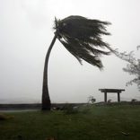
Weather Alert: Strong winds and rough seas forecasted for southern Mozambique
Cyclone Kenneth Category 4, rapidly approaching Mozambique, Tanzania
10:42 CAT | 25 Apr 2019

Image via Twitter: SA Weather Service @SAWeatherService
Tropical Cyclone Kenneth, which is hurtling towards the northern regions of Mozambique, has been upgraded to a Category 4 storm.
The grim arrival of Cyclone Kenneth comes in the recent wake of one of Southern Africa’s worst tropical disasters. Cyclone Idai ravaged Mozambique in March, costing at least 1000 people their lives, leaving thousands more destitute and damaging vital infrastructure, including healthcare facilities and power generating units.
This is terrifying.
Cyclone Kenneth is growing rapidly and headed for Mozambique.
It’s been barely more than a month since Cyclone Idai hit Mozambique — triggering the worst weather disaster in Southern Hemisphere history.
Kenneth will worsen an already horrific tragedy. pic.twitter.com/2zipiPY2sz
— Eric Holthaus (@EricHolthaus) April 23, 2019
Devastation also spread to Malawi and Zimbabwe, displacing and embattling almost 3 million people. Idai is on record as being one of the worst tropical cyclones to impact Africa and the Southern Hemisphere. It also ranks as the third-deadliest tropical cyclone ever recorded.
While Mozambique continues to count the cost of Cyclone Idai, slowly sifting through the unparalleled destruction, housing the displaced and attempting to contain a vicious Cholera outbreak, yet another storm is due to impact the embattled nation later this week.
Cyclone Kenneth expected to make landfall on Thursday night
#CycloneKenneth is heading for northern Mozambique’s Cabo Delgado province and will make landfall on Thursday evening.
Wind speeds of 150 km/h will lash the coastline upon landfall and >300 mm of rain is expected from Thurs. to Sat. over a large part of the province. #eNCA pic.twitter.com/XWkZt0PPrZ
— eNCAWeather (@eNCAWeather) April 24, 2019
Worryingly, Cyclone Kenneth, which began to form above the Indian Ocean on 21 April, has recently been upgraded to Category 4, with wind speeds estimated to exceed 215 km/h. Cyclone Idai made landfall at Category 3 and resulted in unmitigated ruin.
Fearing the worst, evacuation procedures have already been implemented in northern Mozambique and Tanzania. According to Storm Report SA:
“Kenneth could possibly be one of the strongest cyclones to hit Eastern Africa that close to the equator. It will likely bring impact to Tanzania too – the country rarely receives any tropical cyclone impact.”
The island nation of Comoros has already felt the impact of Cyclone Kenneth, which has forced the closure of all airports and schools.
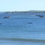
Cyclone Kenneth is expected to bring with it in excess of 200 mm of rainfall and an oceanic storm surge of around 4 metres. These compounded conditions are likely to result in widespread flooding, particularly in coastal regions.
By Luke Daniel
Intense Tropical Cyclone #Kenneth is still tracking west and is expected to move over the north-eastern parts of Mozambique later today. Wind in excess of 200km/h is expected with heavy rain and flooding as well as storm surge along the coast. #Mozambique pic.twitter.com/4QU74eKLBB
— SA Weather Service (@SAWeatherServic) April 25, 2019
25/04 09h00 Past 24hr SSEC cloud tops (temp) IR animated satellite image of tropical cyclone Kenneth (CAT 4), eye forming before it makes landfall this today. pic.twitter.com/i6dVCxl84k
— Dullstroom Weather (@Dullsweather) April 25, 2019
#CycloneKenneth: Le @Prefet976 maintient les vigilances forte houle et orages sur #Mayotte. De nombreux dégâts aux #Comores, balayées par des vents >200km/h. L’oeil est passé près du nord de la Grande Comores. #Kenneth poursuit sa route vers le Mozambique en cat.4 ?@LouisWitter pic.twitter.com/gwLfYVJWwK
— Outremers360 (@outremers360) April 25, 2019
Source: The South African
Show comments
Also read


Leave a Reply
Be the First to Comment!
You must be logged in to post a comment.
You must be logged in to post a comment.