
Mozambique: Quelimane invests $150,000 in youth-led climate action projects
Cyclone Chalane in Mozambique Channel – AIM report
4:38 CAT | 28 Dec 2020
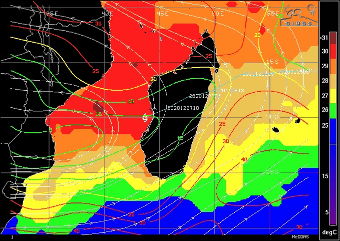
Image: Twitter / @jnmet
Tropical cyclone Chalane entered the Mozambique Channel on Monday morning, after crossing Madagascar.
Spending two days over land weakened the cyclone, but it did not dissipate, although it was downgraded from a cyclone to a depression. Over open water, however, it will now intensify. According to the Joint Cyclone Warning Centre (JTWC), operated by the United States navy, on its entry into the Mozambique Channel, the cyclone was generating winds of 35 knots (65 kilometres an hour), with gusts of 45 knots.
Light shear and very warm water should allow #Chalane to regain moderate or even severe TS intensity before striking central #Mozambique on Wednesday. Many of these areas are still struggling to recover from Intense TC #Idai back in mid- to late-March 2019. pic.twitter.com/61xU3IrGSF
— Jason Nicholls (@jnmet) December 28, 2020
Chalane is now heading directly west, on a course that will bring it to the Mozambican coast on Wednesday morning. The JTWC forecasts that it will make landfall near Beira, with a wind speed of 120 kilometres an hour.
The Mozambican National Meteorology Institute (INAM) warns of heavy rains (100 millimetres in 24 hours) in Beira, in all of southern Sofala, and in much of the neighbouring province of Manica, including the provincial capital, Chimoio.
Rains of over 50 millimetres in 24 hours are expected in the northern parts of Sofala and Manica, in most of Zambezia, and in the northern districts of Inhambane.
Source: AIM
Show comments
Also read


Leave a Reply
Be the First to Comment!
You must be logged in to post a comment.
You must be logged in to post a comment.