

Death toll from floods rises to nine in southern Mozambique - AIM report
Cheneso: Cyclone hits Madagascar but no threat to Mozambique – AIM
8:07 CAT | 19 Jan 2023
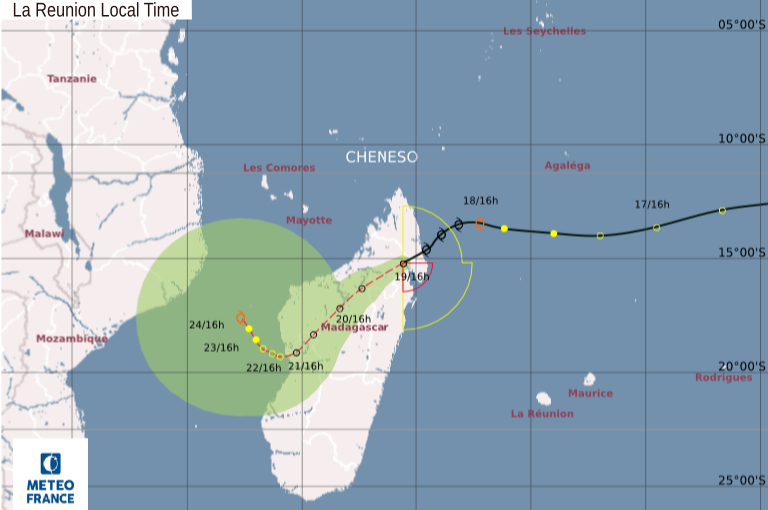
Image: Meteo France via Zim Cast on Twitter
A tropical cyclone, named “Cheneso”, has formed in the Indian Ocean and is currently battering the northern tip of Madagascar.
Madagascar has registered winds of up to 100 kilometres an hour, with gusts of up to 130 kilometres an hour. The storm has also brought torrential rain to coastal parts of the northern Mozambican province of Nampula.
However, the storm system is expected to dissipate, as it tracks inland over northern Madagascar. According to the US Joint Typhoon Warning Centre (JTWC), it entered Madagascar with an average windspeed of 45 knots (65 kilometres an hour), but this is expected to fall to 20 knots by Saturday morning. The cyclone will then dissipate, and thus presents no threat to the southern African mainland.
This is the usual performance of tropical cyclones, which intensify over water, but weaken over land.
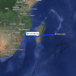
Severe TS #Cheneso had made landfall near Antalaha, #Madagascar and will weaken but heavy rain & flooding will remain a concern into at least Monday. The depression can enter the #Mozambique Channel late Sunday or Monday. Mozambique should monitor for possible impacts next week. pic.twitter.com/WILpCSJjrA
— Jason Nicholls (@jnmet) January 19, 2023
There is still no clear trajectory for #Cheneso, however Mozambique should be prepared for possible impact. Cheneso will move close to the western coast of Madagascar by Monday next week. Projections should be clearer by this weekend. pic.twitter.com/lcg1e4wCeN
— ZIMCAST (@ZIM_CAST) January 19, 2023
Source: AIM
Show comments
Also read


Leave a Reply
Be the First to Comment!
You must be logged in to post a comment.
You must be logged in to post a comment.