

South Africa's DA party withdraws from national dialogue amid coalition dispute
ALERT: Southward bound Cyclone Enawo hits Madagascar with 220km/h winds, steering clear of Moz, SA
2:48 CAT | 07 Mar 2017
Météo-France
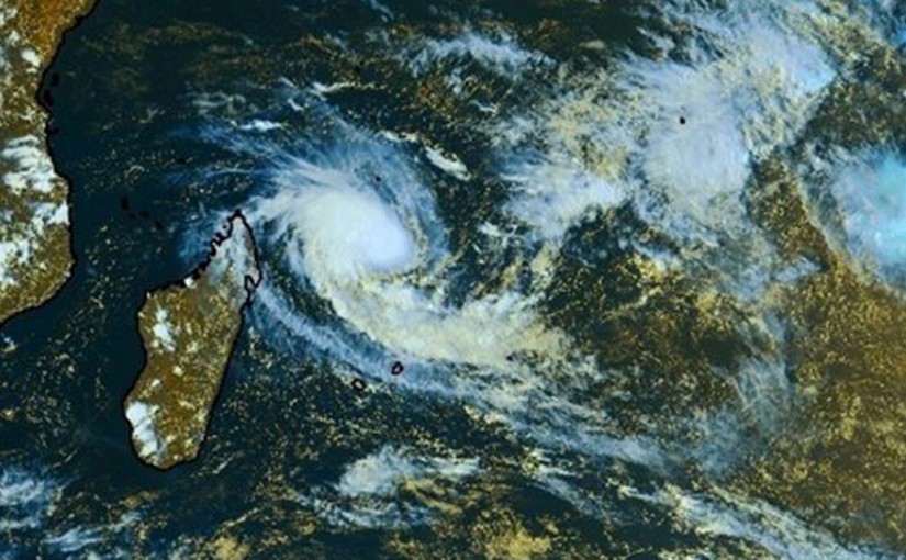
Intense Tropical Cyclone Enawo, whose name originated from Malawi, has just made landfall over the north-eastern parts of Madagascar, near the town of Antalaha.
According to the South Africa Weather Service’s Chief Forecaster Ezekiel Sebego, the cyclone has maximum average wind speeds of about 220 km/h and torrential rains, with conditions expected to persist until Friday as it moves back over open water around the south-east of Madagascar.
However Sebego says the weather service can state with confidence that there is no concern about this weather system for South Africans at all.
Last month parts of the country were severely affected by the effects of Cyclone Dinoe, which although downgraded to a tropical storm it brought with it wind speeds in excess of 65km/h and heavy rainfall.
Enawo will follow a track southwards
“It is then expected that Enawo will follow a track southwards, through the drought-stricken island state during the next few days. Heavy rains are expected over most of the island, especially over the eastern parts where there are mountains running parallel to the coast.
Even though the winds are expected to moderate upon landfall, gale force (atleast 65km/h) are expected to persist along the island’s east coast until Friday,” says Sebego.
“The storm’s path thereafter has now become clearer and is expected to continue on a southward track into the higher latitudes, staying well clear of South Africa and Mozambique.”


The South African Weather Service says it will continue to monitor any further developments relating to this weather system and will issue subsequent updates as required.
Source: Traveller 24
Show comments
Also read


Leave a Reply
Be the First to Comment!
You must be logged in to post a comment.
You must be logged in to post a comment.