

Zambian ex-president's family settle funeral row with government
Indian Ocean: Severe Tropical Storm Gamane tracking south-southeastward off the northeast coast of Madagascar as of March 26
4:54 CAT | 26 Mar 2024
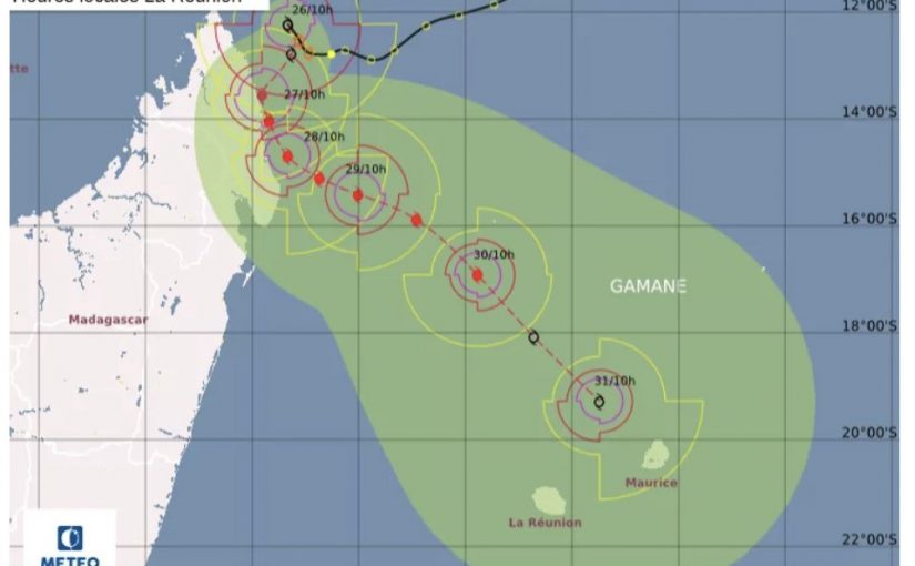
Image: Meteo France
- TS Gamane tracking south-southeastward in the Indian Ocean March 26. Landfall forecast over Sava Province, Madagascar, late March 27.
Severe Tropical Storm Gamane is tracking south-southeastward off the northeast coast of Madagascar March 26. As of 15:00 EAT, the storm’s center of circulation was approximately 1,098 km (682 miles) northwest of Port Louis, Mauritius.
Forecast models indicate the system will strengthen into a tropical cyclone March 27 as it tracks generally south-southwestward toward northeastern Madagascar. Gamane is expected to make landfall over Sava Province between Vohemar and Sambava late March 27 before skirting southward along Sava’s coastline through March 28. The system is expected to weaken into a severe tropical storm as it moves back into the Indian Ocean late March 28 and tracks southeastward away from Madagascar March 29-30. Gamane is expected to weaken further into a moderate tropical storm as it approaches the Mascarene Islands March 31. Some uncertainty remains in the track and intensity forecast, and changes could occur in the coming days.
As of March 26, Meteo Madagascar has issued yellow cyclone warnings (the middle level on a three-tier scale) for the Analjirofo, Diane, and Sava regions. Yellow heavy rainfall warnings have been issued across the Atsinanana Region and Belalanana, Befandriana, and Mandritsara districts of the Sofia Region, and green heavy rainfall warnings are in place across Alaotra-Mangoro Region. Red strong wind and heavy swell warnings are in place for much of Madagascar’s eastern, northeastern, and southern coastlines. Weather conditions are reportedly already deteriorating in northern and northeastern parts of the country and will spread into eastern regions late March 26. Heavy rainfall is expected to persist in parts of Analjirofo, Diane, and Sava regions through at least March 28 and could trigger widespread flooding and landslides in affected areas. Storm surge is possible in coastal areas of Sava March 27 as the system approaches land, and maritime operators have been advised not to venture out to sea between Antsiranana and Mahanoro due to dangerous sea conditions.
Sustained heavy rainfall could trigger flooding in low-lying areas and those with easily overwhelmed drainage systems. Localized evacuations, flash flooding, and landslides are possible. The inclement weather could trigger localized business, transport, and utility disruptions, rendering some bridges or roadways impassable. Flight disruptions at regional airports and temporary closures of ports are also possible. Stagnant pools of water during and after flooding increase insect- and waterborne diseases, such as dengue fever, cholera, and malaria. Raw sewage and other hazardous materials mixed with floodwaters pose a serious health threat.
Tropical Storm #GAMANE nears #Madagascar‘s east coast, expected to intensify into a cyclone within 24h.
Expected to approach Diego Suarez province by midday tomorrow 27/03, bringing heavy rains and landslides, SAVA, DIANA, and Analanjirofo regions are on yellow alert. pic.twitter.com/9sj2sUGPJf— IFRC Africa (@IFRCAfrica) March 26, 2024
Source: Crisis24
Show comments
Also read


Leave a Reply
Be the First to Comment!
You must be logged in to post a comment.
You must be logged in to post a comment.